A Proposal for the Stanley J. Bushman Supporting Foundation
Bringing More
People to the
Power of
Live Music.
A visionary venue that amplifies the impact of the Kansas City Symphony.
Explore
A Proposal for the Stanley J. Bushman Supporting Foundation
A visionary venue that amplifies the impact of the Kansas City Symphony.
We are honored to receive the $1,000,000 gift from the Stanley J. Bushman Supporting Foundation, and I'd love to propose how this is allocated, and how we can recognize Stan.
Stan's generosity comes at a crucial moment for the Symphony: we are preparing to build a new, state-of-the-art music venue for amplified concerts that will generate millions of dollars in annual support for the Symphony. Designed as a welcoming home for international touring artists across genres, we estimate this venue will attract over 300,000 people each year. The revenue it generates will be reinvested in our artistic and community initiatives and provide real economic benefits to Kansas City.
We suggest allocating Stan's remarkable $1,000,000 gift to the capital campaign we've launched to build this venue, which will generate an immediate and substantial return for the Symphony. Specifically, his donation will help accelerate the building's completion and ensure that the Film + Live Orchestra program, one of our most popular, in-demand offerings, has a world-class technical home.
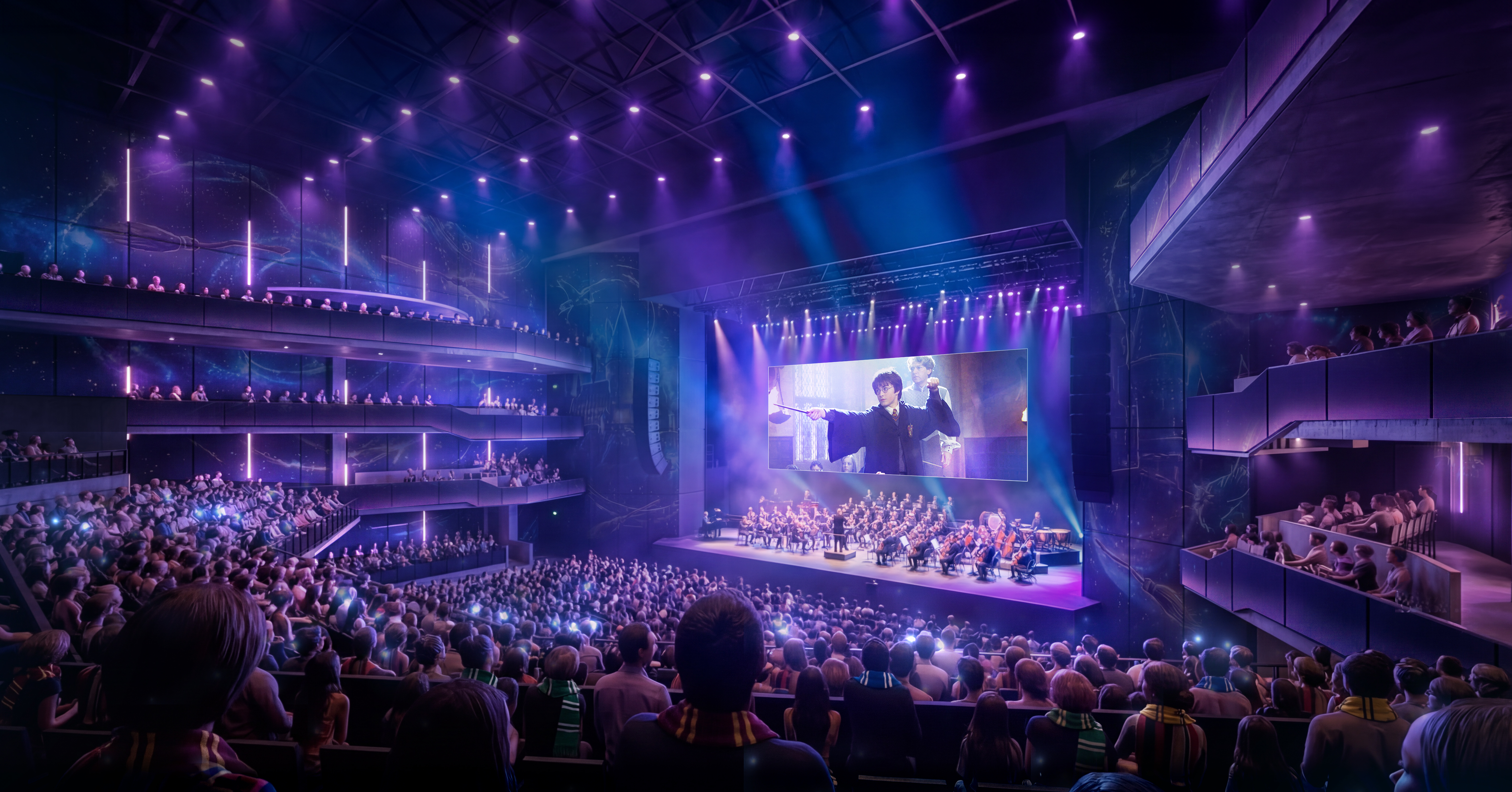
Our Film with Live Orchestra series beautifully fulfills the ambition that Stan, Charley and I discussed many times, which is to enable the Symphony to reach as many people as possible in the Kansas City region. Our live soundtracks to popular films have brought hundreds of thousands of people to the Symphony. Our venue will be the first in the world constructed specifically for this purpose.
To honor Stan's leadership, his entrepreneurial energy and his vision for expanding audiences, we suggest the following recognitions linked to the Film + Live Orchestra series.
I'm grateful to you and Stan for sharing our vision of a universally accessible symphony and for believing in a bold next chapter. I would welcome a conversation to ensure the allocation and recognition align with Stan's wishes.
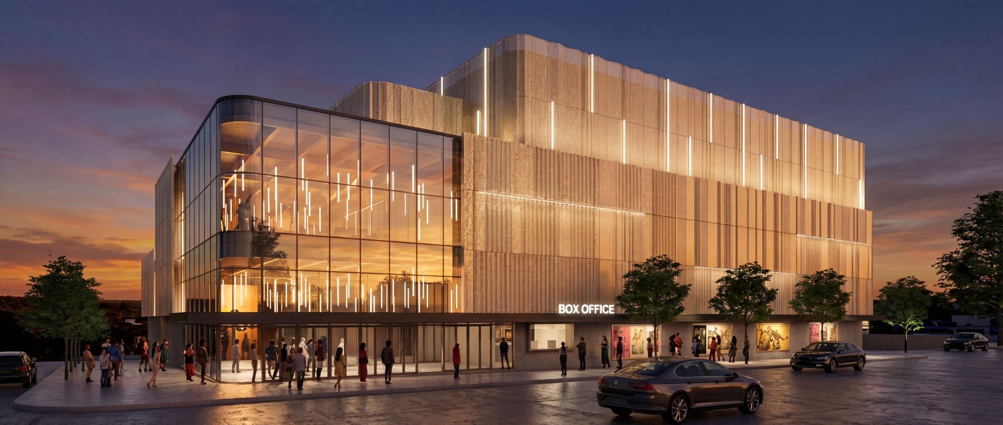
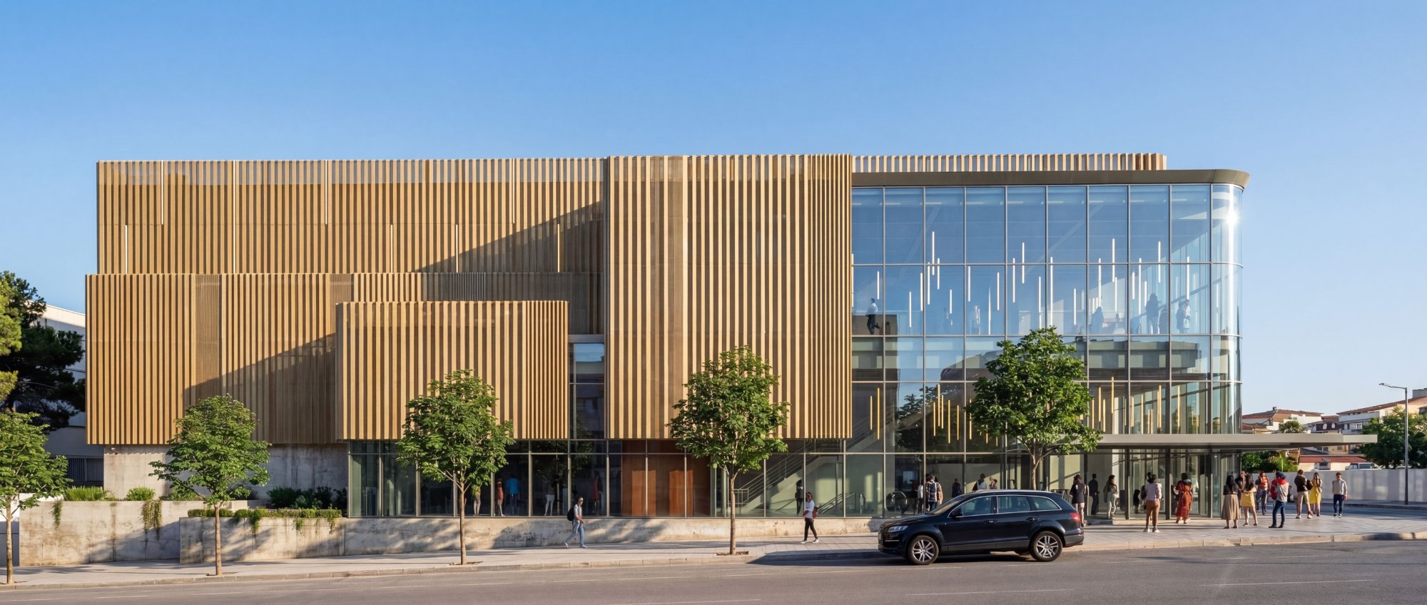
Kansas City's culture is grounded in live music—it builds community, fuels civic pride, and shapes our region's identity. Today's music market increasingly favors flexible, mid-sized, and tech-forward venues built for immersive experiences and the Kansas City Symphony is ready to bring that venue to the city we call home.
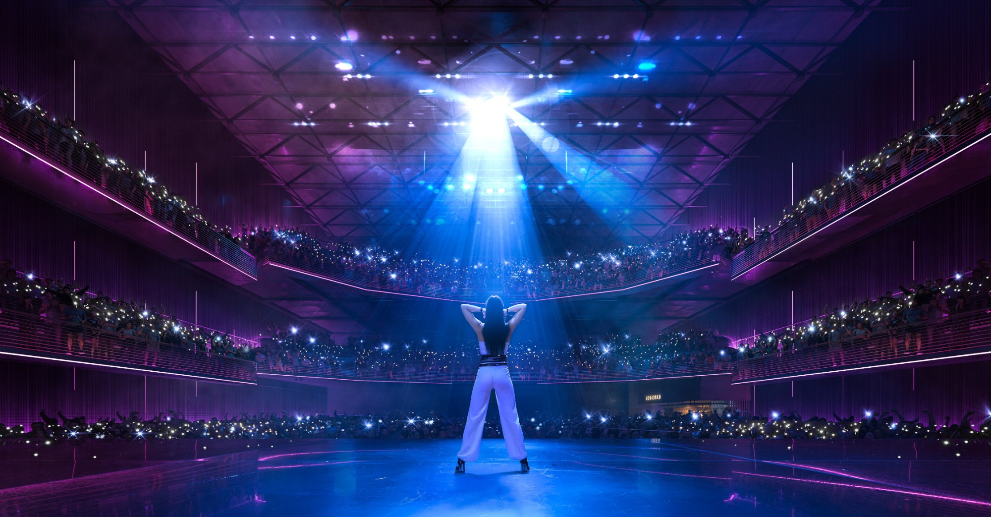
We are building a touring-ready, all-genre, mid-sized indoor venue designed for contemporary music and amplified orchestral experiences.
Locally controlled, mission-driven ownership ensures every dollar stays in Kansas City.
A proven nonprofit partner affiliated with a peer orchestra of ours - the Cincinnati Symphony.
Home to our Film with Live Orchestra series and programming across every genre, designed to welcome people who've never experienced a symphony.
The Symphony's primary performance home will always be the Kauffman Center. This new venue is a strategic extension that will enable us to perform and present amplified music at the same level that we perform acoustic music in Helzberg Hall, while ensuring the longevity of the Symphony for generations.
Expanding the Symphony's ability to deliver the programming Kansas City audiences love.
A purpose-built space for immersive, technology-driven live music experiences.
A permanent source of income that strengthens the orchestra for generations.
Inspired by celebrated venues such as Denver's Mission Ballroom, Cincinnati's Andrew J. Brady Center, and Washington, D.C.'s The Anthem, this venue is designed with the same ambition to create powerful, shared moments between artists and audiences.
An explosion of artists and rising demand for live experiences has fueled a music boom, with 74% of the younger generation attending a live show in the past year. With this growing market, audiences and artists seek more intimate venues that transform with performances. That's what the Symphony is bringing to Kansas City.
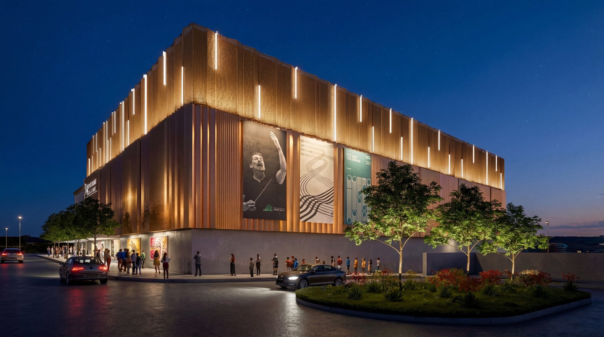
At 49th and Main–steps from the streetcar expansion and surrounded by scores of locally-owned restaurants and shops–the venue will anchor the Plaza's revitalization, drawing 300,000 people to the district year-round.
Purpose-built for today's music landscape—and for the long-term success of the Symphony.
With every seat within 145 feet of the stage and flexible capacity up to 4,600, the venue delivers powerful connection and presence—no matter the performance.
Owned by the Kansas City Symphony and operated by MEMI, a nationally respected nonprofit affiliated with the Cincinnati Symphony, ensuring benefits stay rooted in KC.
It's Kansas City's time for amplification. Designed for clarity and impact with state-of-the-art sound reinforcement that elevates every amplified performance and lets artists deliver their vision exactly as they intend.
With its 72,000 sq ft of space, the venue adapts from seated orchestral films to high-energy general admission shows across genres like hip-hop, rock, country, and R&B.
A welcoming space with diverse programming and tiered ticketing—ensuring more Kansas Citians can experience live music at its best.
This venue creates a permanent source of income that strengthens the orchestra for generations.
This venue is cultural infrastructure, advanced by the Kansas City Symphony to serve Kansas City's long-term cultural and economic vitality. It fills a long-standing gap in our live music landscape, positioning our region to attract artists, audiences, and opportunities that have too often passed us by.
With programming that spans genres, inclusive pricing, and performances that invite new audiences, this space is designed to belong to everyone.
The venue is modeled after similar venues that have seen economic, civic, and cultural success in their respective cities, and have secured financial stability for their local symphonies.
As a year-round cultural anchor, it will welcome hundreds of thousands of guests annually, fueling local restaurants, bars, hotels, and neighborhoods, while building the foundation of long-term financial sustainability of the Symphony for generations to come.
It will also generate jobs across tech, hospitality, and production.
We expect a similar impact in Kansas City's economy and labor force to what Cincinnati has experienced with the Brady Center:
This venue is an investment in infrastructure that shapes and strengthens civic life in the city we love. Locally owned and mission-driven, every event at this venue reinvests directly into the creative heart of Kansas City, and the Kansas City Symphony.
Music defines Kansas City's cultural life, and the Kansas City Symphony has long worked to ensure it remains accessible and enduring. This venue is how we extend this commitment, and it's only possible through philanthropic leadership.
Philanthropic support for this venue will:
Stan knows what music can do. He's seen how it creates joy, reaches new audiences, and makes our city feel like home.
Together, we can create a landmark not only for today's performers but for generations to come, fueling civic pride and strengthening community bonds through the unmatched power of live music.